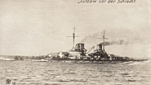
Lutzow Wreck
| Field |
Value |
| Wreck Category |
non-dangerous wreck |
Lutzow Wreck Location
Marine Coordinates (DMM)
|
56 16.66 N,5 39.987 E |
Latitude, Longitude
Decimal Degrees
|
- Latitude: 56.277667
- Longitude: 5.666450
|
| Wreck Depth |
36.18 m
|
| Water Depth |
42 m
|
| Water Level Effect |
always under water/submerged |
| Vertical Datum |
Approximate Lowest Astronomical Tide |
| Name |
LUTZOW |
|
Type
|
battle-cruiser
|
| Flag |
DE |
| Length |
210 m |
| Width |
29 m |
| Draught |
8.2 |
| Sonar Length |
181 |
| Sonar Width |
32 |
| Shadow Height |
6.4 |
| Orientation |
15 |
| Tonnage |
26600 |
| Tonnage Type |
displacement |
| Conspic Visual |
not visually conspicuous |
| Conspic Radar |
not radar conspicuous |
| Date Sunk |
May 31, 1916
|
| Bottom Texture |
Sand |
| Scour Dimensions |
,,003.0, |
| Original Detection Year |
1916 |
| Last Detection Year |
2021 |
| Original Source |
other |
| Last Amended Date |
Apr 7, 2021 |
Surveying Details
H3468/20 SUNK IN 561700N, 052800E APPROX. (AUTHORITY NOT STATED) CHART AS WK [OLD SYMBOL]. H315/27 12.2.27 NOW CHARTED AS NDW PA (1916). (AUTHORITY NOT STATED) NE 2182B. H3927/60 1.9.60 SALVAGE OPS REPORTED IN PROGRESS IN 561700N, 054100E. (HAMBURG NM 2582/60). H3927/60 13.9.60 SALVAGE OPS COMPLETED. (HAMBURG NM 3510/60). NCA. 31.7.72 WK SHOWN IN 561710N, 052750E ON DANISH FISHERIES 5604 [REC'D 1965]. 12.1.84 SHOWN AS NDW IN 561700N, 052800E [EUR] ON DANISH 93 (INT 1044) [0CT'83 EDN]. HH100/351/04 29.7.91 DIVED ON IN 1990 IN 561642N, 053901E BY DANISH DIVERS. POSITIVELY IDENTIFIED, NAME PLATE RECOVERED. REGULARLY FISHED. POSN CONSIDERED LIKELY TO BE VERY ACCURATE. (BATTLE OF JUTLAND - 75TH ANNIVERSARY EXPED. REPORT 3.7.91). AMEND POSN. BR STD. SEP 2011/000014970 24.2.11 NOT SHOWN ON DANISH 93 [NE DTD 12.2010]. DELETE. BR STD. SEP 2015/000111115 24.7.15 NOT LOCATED, NFS. (HMS ECHO, SNT03/15). NCA. SEP 2015/000191865 2.9.15 EXAM'D 29.8.15 IN 5616.636N, 0539.966E [WGD]. LEAST M/B DEPTH 36.28MTRS IN GEN DEPTHS 42MTRS. LENGTH 181MTRS, WIDTH 32MTRS. SCOUR DEPTH 3MTRS, RUNNING ALONGSIDE NW SIDE OF THE WRECK. UPTURNED, BOWS SW. (HMS ECHO, SNT03/15). AMEND TO NDW 36MTRS IN REVISED POSN. 21.9.15 EXAM'D 29.8.15 IN 5616.660N, 0539.987E [WGD]. LEAST M/B DEPTH 36.18MTRS IN GEN DEPTH 42MTRS, LENGTH 181MTRS, WIDTH 32RS, HT 6.4MTRS, ORIENTATION 015/195. WRECK APPEARS TO BE IN ONE PIECE, UPSIDE DOWN WITH BOWS LYING TO THE SW. (HMS ECHO H102/14/15 AND SNT0315_H525_11, DTD 30.8.15). MOVE TO REVISED POSN. - NM 5035/15. SEP 2016/000072600 13.4.16 NDW SHOWN IN 5616.660N, 0539.987E [WGD]. DENMARK 93[ED 8 CORR TO 26/02/16]. AMEND TO NDW IN REVISED POSN.
Circumstances of loss
TORPEDOED BY HMS ACASTA DURING THE BATTLE OF JUTLAND AFTER PREVIOUSLY BEING BADLY DAMAGED BY GUNFIRE FROM HM SHIPS LION AND PRINCESS ROYAL. SHE BECAME UNMANAGEABLE, WAS ABANDONED BY CREW AND EVENTUALLY SANK.
WRECK MAP LOADING ...
56 16.66 N,5 39.987 E
Lutzow on Wreck Map
Lutzow Wreck on Google Map
FAQ
Where is the LUTZOW wreck located?
The LUTZOW wreck is located at coordinates 56 16.66 N,5 39.987 E.
How deep is the LUTZOW and where exactly is it located?
The LUTZOW lies at a depth of about 36.18 meters and is located at coordinates 56 16.66 N,5 39.987 E.
How deep is the seabed around the LUTZOW?
The seabed around the LUTZOW lies at approximately 42 meters deep.
When did the LUTZOW sink?
The LUTZOW sank on May 31, 1916.
When was the wreck of the LUTZOW discovered?
The wreck of the LUTZOW was discovered in 1916.
What country did the LUTZOW belong to?
The LUTZOW belonged to DE.
What was the tonnage of the LUTZOW?
The LUTZOW had a tonnage of 26600 tons.
What type of wreck is the LUTZOW?
The LUTZOW is classified as a battle-cruiser.
General Comments
UPTURNED, BOWS SW.