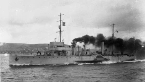
Hms Ascot Wreck

Field Value
Wreck Category non-dangerous wreck
Hms ascot Wreck Location
Marine Coordinates (DMM)
55 37.927 N,1 29.863 W
Latitude, Longitude
Decimal Degrees
  • Latitude: 55.632117
  • Longitude: -1.497717
Wreck Depth 50 m
Water Depth 54 m
Water Level Effect always under water/submerged
Vertical Datum Approximate Lowest Astronomical Tide
Name HMS ASCOT
Type minesweeper
Flag GB
Length 75 m
Width 8.8 m
Draught 2.1
Sonar Length 58
Sonar Width 13
Shadow Height 5
Orientation 12
Tonnage 810
Tonnage Type gross
Conspic Visual not visually conspicuous
Conspic Radar not radar conspicuous
Date Sunk Nov 10, 1918
Bottom Texture Sand
Original Detection Year 1918
Last Detection Year 1999
Original Source other
Surveying Details H0167/17 22.11.18 INS WK IN 553600N, 013200W. (AP REPORT TYNE). H4214/26 1.7.26 AMEND TO NDW PA (1918). BA 1192. 17.4.45 POOR SONAR CONTACT, POOR POSN 553554N, 013024W. (AUBD 311/16, EG 30, 17.4.45). H1309/74 24.2.75 IN 1974 A SHAFT AND ATTACHED PADDLE FRAME WAS BROUGHT INTO SEAHOUSES. THIS IS THOUGHT TO BE FROM THE WK OF HMS ASCOT. NO OTHER DETAILS. (P BAKER, 22.2.75). H1280/77 2.3.77 POSN GIVEN AS 553600N, 013200W. (W MCINTOSH, LTR DTD 6.1.77). H4622/71 14.9.72 AMEND TO USCPA 20MTRS. NC 160. HH100/351/15 20.9.99 LIES IN 5539.724N, 0129.860W [WGD]. WK HAS COLLAPSED AND IS WELL BROKEN UP ON THE SEABED. EXCEPT FOR THE FOUR BOILERS, THE ENGINE AND A JUMBLE OF MACHINERY, THE LARGEST PIECE OF STEEL STRUCTURE STANDS ABOUT 4MTRS HIGH. REMAINS OF BOTH PADDLE WHEELS ARE APPARENTLY STILL IN PLACE. UPPER BRIDGE HAS COLLAPSED IN A PILE. POSN GIVEN BY A ANDERSON. WK HAS BEEN VERIFIED AS 'ASCOT'. (R YOUNG & TELECON AMENDING POSN DTD 8.5.00). AMEND TO USC 40MTRS IN REVISED POSN. BR STD. HH090/843/01 21.12.99 EXAM'D 1.7.99 IN 5537.927N, 0129.863W [WGD] USING DGPS. LEAST E/S DEPTH 50.0 IN GEN DEPTH 54.4MTRS. NO SCOUR. LENGTH 58MTRS, WIDTH 13MTRS. DCS3 HT 5MTRS. LIES 012/192 DEGS. DEBRIS EXTEND 7MTRS TOWARDS 197 DEGS. POOR MAGNETIC ANOMALY. SEABED SAND. WELL BROKEN UP. (GARDLINE, HI 843). INS AS WK 50MTRS. BR STD.
Last Amended Date Jun 5, 2007

Circumstances of loss

BUILT AS A PURPOSE BUILT MINESWEEPER IN 1916 BY AILSA SHIP BUILDING CO. STEEL HULLED. FOUR BOILERS, TRIPLE EXPANSION ENGINE OF 1400 HP, PADDLE PROPULSION. CARRIED A SOPWORTH PUP SEAPLANE, 1 X 3 INCH AND 2 X 2 LB GUN. SUNK BY GERMAN SUBMARINE UB 67. CREW OF 50 ALL LOST. ASCOT WAS THE LAST VESSEL SUNK BY GERMAN U-BOATS IN THE 1914-18 WAR.

General Comments

WELL BROKEN UP

WRECK MAP LOADING ... 55 37.927 N,1 29.863 W
Hms Ascot on Wreck Map Hms Ascot Wreck on Google Map

Nearby Wrecks:

FAQ

Where is the HMS ASCOT wreck located?

The HMS ASCOT wreck is located at coordinates 55 37.927 N,1 29.863 W.

How deep is the HMS ASCOT and where exactly is it located?

The HMS ASCOT lies at a depth of about 50 meters and is located at coordinates 55 37.927 N,1 29.863 W.

How deep is the seabed around the HMS ASCOT?

The seabed around the HMS ASCOT lies at approximately 54 meters deep.

When did the HMS ASCOT sink?

The HMS ASCOT sank on Nov 10, 1918.

When was the wreck of the HMS ASCOT discovered?

The wreck of the HMS ASCOT was discovered in 1918.

What country did the HMS ASCOT belong to?

The HMS ASCOT belonged to GB.

What was the tonnage of the HMS ASCOT?

The HMS ASCOT had a tonnage of 810 tons.

What type of wreck is the HMS ASCOT?

The HMS ASCOT is classified as a minesweeper.