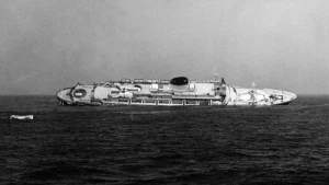
Andrea Doria Wreck
| Field | Value |
|---|---|
|
Andrea doria Wreck Location Marine Coordinates (DMM) |
40 29.400 N,69 51.050 W |
| Latitude, Longitude Decimal Degrees |
|
| Reported Year | 1956 |
| Name | ANDREA DORIA |
| Type | transport vessel |
| Flag | Italy |
| Length | 212.1 m |
| Width | 27 m |
| Draught | 13.8 |
| Tonnage | 29100 |
| Tonnage Type | gross |
| Date Sunk | Jul 24, 1956 |
Circumstances of loss
COLLISION W/ "STOCKHOLM"
On July 17, 1956, the Andrea Doria left Genoa, Italy, for a nine-day voyage to New York with 1,706 passengers and crew on board. Late on July 25, while sailing through thick fog near Nantucket, the ship detected the MS Stockholm on radar. Although both crews tried to avoid each other, they misunderstood their positions and chose opposite passing sides.
At around 11:10 p.m., the two ships collided. The Stockholm crashed into the starboard side of the Andrea Doria, tearing through several decks. The Stockholm was badly damaged but stayed afloat. The Andrea Doria quickly began to lean, making half of its lifeboats impossible to use.
Rescue ships, including the Stockholm and the Ile de France, helped evacuate passengers and crew. Even though 51 people lost their lives, many more were saved because of the fast rescue effort. Around 10:09 a.m. on July 26, nearly 11 hours after the collision, the Andrea Doria rolled over and sank.
Investigators later concluded that the disaster was caused by a combination of heavy fog, excessive speed in poor visibility, and mistakes in using radar. The Stockholm was repaired and continued operating for many years under different names and owners.
Nearby Wrecks:
- Andrea Doria Wreck 1404.9 M
- Unknown Wreck 114015 1410 M
- Unknown Wreck 117138 8395.9 M
- Unknown Wreck 117561 8395.9 M
- Unknown Wreck 114025 8413.2 M
- Unknown Wreck 113413 17622.8 M
- Skipper Wreck 18139.8 M
- Unknown Wreck 113479 18252.9 M
- Republic Wreck 18490.1 M
- Valiant Lady Wreck 20531 M
General Comments
Owner: Societa di Navigazione Italia, Year Built: 1950, Where Built: Genoa, Italy, Construction: Steel, Home Port: Genoa, Italy, Departure Port: Genoa, Italy, Destination Port: New York, NY, Master: Piero Calamai, Crew: 575, Passengers: 1241, Lives Lost: 47, Misc Information: sank in 11 hours